Protecting Oceans, Saving Lives
Poseidon turns satellite imagery into real-time maps showing where drifting plastics threaten human health—and how to intervene.
Why Poseidon?
Toxins are increasing across ecosystems and the food chain due in part to the plastic pollution in our oceans and waterways. Concern has risen that this plastic has entered fish
and other sea life, which then lead to potentially dangerous levels of bioaccumulated toxins in humans who consume that food supply.
While not yet conclusive, research suggests this bioaccumulation of plastics, microplastics, and their associated toxins harms human health. To help address this concern,
HSR.health developed a Poseidon Plastic Tracking System to identify the presence and quantity of plastics in our oceans where populations at-risk from such exposure - short and long
term - live.
Poseidon Plastic Tracking System: Protecting Oceans, Safeguarding Lives
Poseidon orchestrates diverse data and technology including geospatial visualization, AI/ML analytics, satellite imagery, and advanced simulations
to forecast the impacts of plastic contamination and guide interventions that protect both the environment and public health.
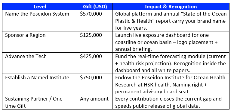
How You Can Help
Every dollar accelerates free public access to Poseidon's exposure dashboard, API, and research archive - turning data into action for at-risk communities and our oceans.
Funding Snapshot:
- Total Project Need: $570,000
- Already Raised: $325,179
- Remaining Gap: $244,821
This isn't a one-time fix. It's a sustainable, continuously updated system that gives the world the insight it needs to act before it's too late.
Poseidon is real. It's working. And with your support, it's ready to spread out across the world.
You can donate online or contact us for custom collaboration. Your support helps bring Poseidon to life.
Impact@HSR.health | +1 240-731-0756
“You're not just funding technology. You're protecting families, ecosystems, and futures.” - Paul A Churchyard, MS, HSR.health CTO
In The News
For more information on how Poseidon is fighting ocean plastic pollution:
- Group on Earth Observations (GEO) blog.
- GeoAI Podcast episode - Raising Awareness & Saving Our Seas - featuring our pilot funders and sponsors - U.S. NOAA, USGS, and Natural Resources Canada (NRCan).
- Read our Engineering Report, recent blogs, and watching our pilot webinar.
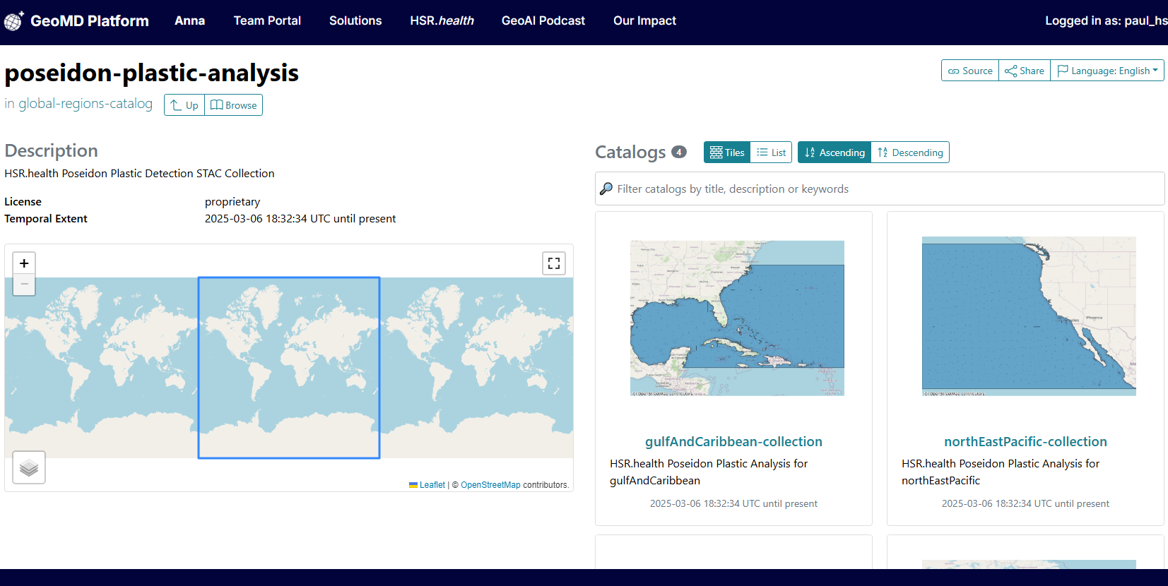
Poseidon STAC Catalog
To increase accessibility & transparency, we've established a SpatioTemporal Asset Catalog (STAC) — a structured, open-data platform enabling:
Researchers & policymakers to explore Sentinel-2 satellite imagery of plastic pollution
Data-driven intervention strategies based on real-time geospatial insights
Efficient global collaboration for ocean plastic tracking
Benefits
This dataset allows for:
- The identification of populations at-risk for adverse health outcomes from bioaccumulation exposure.
- The identification of plastic accumulation in our oceans and waterways.
- The trend of this accumulation over time, which is key to implementing measures to assess the short — and long — term impacts of plastics on our environment and the health of all living creatures in the environment.
- The development of policies to manage microplastic pollution, especially near regions with vulnerable ecosystems and populations.
Spatial Coverage
Poseidon and its underlying datasets have been calculated for Canada and the North American Arctic. These dataset can be made available for any region or body of water globally.
Temporal Coverage
2010 - Current. Incorporating historical trend analysis, continuous updates, as well as forecasting across multiple years can be accomplished upon request based on the temporal coverage of the underlying datasets. Sea Surface Plastic detection is a current snapshot taken at the time the dataset is created.
Process Description
Poseidon's Plastic Bioaccumulation Health Risk Index is based on the health and social factors influencing a person's vulnerability to adverse health outcomes from bioaccumulation of plastics and includes factors such as - age, chronic health conditions, and whether pregnant or breastfeeding. Additionally, leveraging imagery from the Sentinel-2 satellite constellation along with map algebra algorithms from Sentinel Hub (Sentinel Hub 2023) and a plastic detection equation from a peer-reviewed study (Biermann, L., Clewley, D., Martinez-Vicente, V. et al. 2020), we can identify plastic presence in oceans and waterways globally. Alternative methods for feature extraction are available upon request.
Data Availability
The dataset is available in multiple formats, partially including:
- Cloud-Optimized GeoTIFF
- CSV
- PNG
- Web Map Service
- Web Feature Service
- OGC API
- Geo-JSON
- GeoParquet
- Spatio Temporal Asset Catalog
- and other user-specified formats.
Progress
This map shows the progress that your funding support has allowed us to make in tracking plastic presence and its potential health risks caused globally.