Overview
Identifying where resources and personnel need to be allocated within affected areas to help the local population is a core part of a disaster response effort. HSR.health utilizes social, environmental, economic, and underlying health conditions data to create a Hurricane Health Risk Index that identifies in advance the health and medical needs of the hurricane-impacted population providing key insights supporting response and recovery efforts.
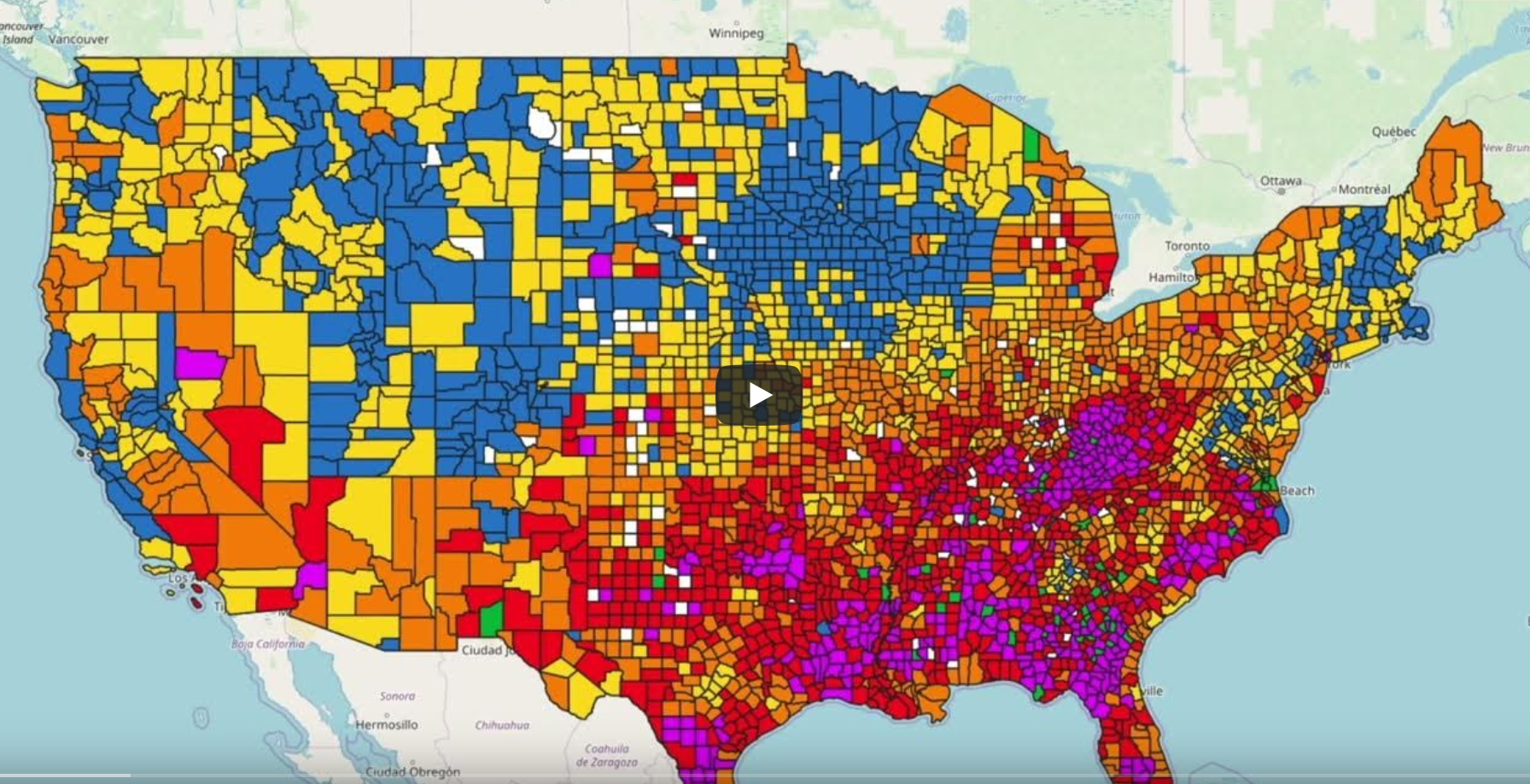
US Hurricane Health Risk Index
With funding support from USGS, NASA, NOAA, and the UK Hydrography Office (UKHO), the Hurricane Health Risk Index was developed across numerous Open Geospatial Consortium pilots.
View the Hurricane Health Risk Index on the AWS Marketplace!Benefits
Informs emergency response personnel, public health officials, governments, economic development, city/civic planners, and global public health organizations the information they need to:
- The identification in advance of the health and medical needs of the population impacted by a hurricane.
- Informing policy decisions for hurricane impacted areas.
- Provides emergency response managers and first responders the necessary decision support guidance to aid response, resource allocation, and evacuation efforts.
Spatial Coverage
The Hurricane Health Risk Index and its underlying datasets have been calculated for the United States, Anguila, The Bahamas, The Commonwealth of Dominica, and can be made available for any nation or region globally based on the availability of the underlying datasets.
Temporal Coverage
2010 – Current. Incorporating historical trend analysis, continuous updates, as well as forecasting across multiple years can be accomplished upon request based on the temporal coverage of the underlying datasets.
Process Description
Along with the storm conditions, the Hurricane Health Risk Index is based on the health and social characteristics of the impacted population – characteristics that
include challenges with mobility, use of powered devices, medical conditions that require regularly scheduled care (e.g., dialysis) – that together define populations
that may be at heightened risk of severe negative health outcomes during and after a hurricane has occurred.
A demonstration of the Hurricane Health Risk Index, produced through funding from USGS, NOAA, and the UK Hydrography Office, for US and Caribbean island nations of
Anguilla, The Bahamas, and the Commonwealth of Dominica for storms that occurred during the 2019 and 2022 hurricane season are available on our
OpenGeoMD Platform.
Data Availability
The dataset is available in multiple formats, partially including:
- CSV
- Web Map Service
- Web Feature Service
- OGC API
- Geo-JSON
- GeoParquet
- and other user-specified formats.
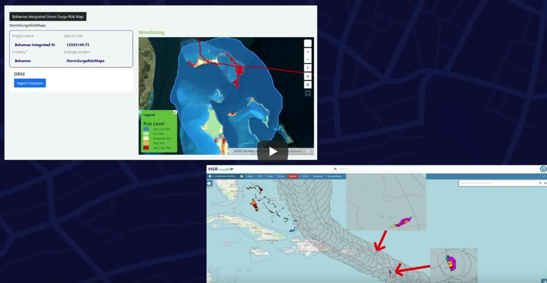
Caribbean Hurricane Health Risk Index
HSR.health Hurricane Health Risk Index for Anguilla, the Bahamas, and the Commonwealth of Dominica with the Hurricane Maria Storm Track overlaid. This persistent demonstrator of the Hurricane Health Risk Index was funded by the UK Hydrography Office as part of the Open Geospatial Consortium's 2023 Federated Marine Spatial Data Infrastructure Pilot. The Engineering Report for the pilot is also available.
Explore the Caribbean Hurricane Health Risk Index on the Open GeoMD Platform! (Coming Soon)